
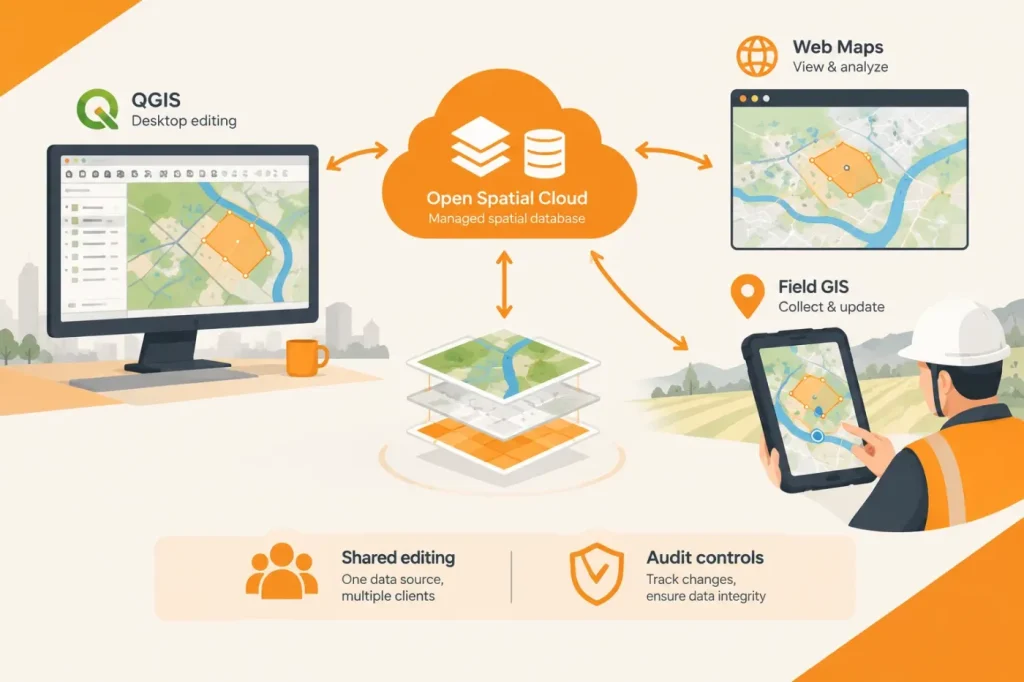

Open Spatial is launching Open Spatial Cloud, a managed GIS platform that connects QGIS desktop editing, browser-based maps and mobile field work to the same hosted spatial data. The company’s launch announcement, published by Geo Week News, describes a service built on PostGIS, GeoServer and OGC standards, with Open Spatial handling hosting, maintenance, security and backups.
The central workflow proposition is to reduce the drift that occurs when desktop projects, web maps, field applications and exported files become separate copies of asset data. Open Spatial says the platform hosts data in one OGC-compliant database, applies shared business rules during editing, and publishes from that source to internal dashboards, public maps and field crews. That is a meaningful change in how teams can organize GIS work: rather than coordinating periodic exports between clients, they can work against shared hosted data.
Three clients make up the described workflow. Enlighten Enterprise provides web viewing, analysis and map publishing; Enlighten Field gives mobile users access to live data; and MunsysQ, a QGIS plugin, connects desktop users to the cloud database through authenticated web services. The release says MunsysQ applies domain values and automated integrity checks as features are drawn, including for utility networks, cadastral data and parcels. This positions QGIS as an editing client within the managed environment, rather than simply a place to prepare files for later upload.
I see shared, rules-based editing as the platform’s most consequential technical choice. The announcement says domain values and integrity checks apply as features are drawn, and that the platform records transaction history. Before treating it as a system of record, I would check a representative edit in QGIS, web and mobile and confirm that the expected validation and transaction history appear in each case; the announcement does not detail conflict resolution or the audit log’s boundaries. Inconsistent checks could allow an invalid edit through one client or leave an incomplete audit trail; that is a risk to test, not an established defect.
The platform also includes role-based access and auditing, with permissions configurable by layer or area; workflow automations and an API; configurable internal and public maps; an embeddable viewer; scheduled reports; and guided in-app tours. Open Spatial says customer data is separated between tenants, encrypted in transit and at rest, and backed up automatically. The company also says customers can choose a hosting region, with environments available in the United States and Australia. Users can sign in using organizational Microsoft or Google accounts, while QGIS access is provided through authenticated services rather than database credentials held by desktop editors.
Those controls could reduce the operational burden of maintaining GIS infrastructure in-house, but the announcement’s security and efficiency statements are vendor claims, not independent performance or security findings. Teams should confirm that available hosting regions, identity integration, data-retention terms and recovery arrangements meet their own requirements. The release does not specify QGIS version compatibility, offline field-editing behavior, migration tooling or service-level commitments.
I see a potential migration obstacle for teams that rely on direct database connections: authenticated web services trade direct database access for centrally managed access. Open Spatial says QGIS editors use those services instead of holding database credentials, with access granted and withdrawn in one place. That may simplify credential control, but it can require changes where an existing database integration depends on direct connections. Before adoption, I would run a representative existing integration through the service or API and verify its required data access, permissions and update workflow; if it requires direct database credentials, the decision rule is whether that integration can be adapted without losing a necessary function.
For local governments, utilities and infrastructure owners already using QGIS, the clearest potential fit is a managed deployment that brings desktop editors and non-specialist map users onto a common data environment. Open Spatial describes an API for connecting spatial data to other enterprise systems, which may help teams coordinate GIS data with wider workflows; the announcement does not establish CAD or BIM authoring integration. Organizations should also confirm that the stated United States and Australia hosting regions, and the unspecified QGIS version and offline-field details, fit their requirements. Open Spatial says the platform is available now and offers a free trial.
Sources
- Open Spatial Announces the Launch of Open Spatial Cloud — Geo Week News
- Open Spatial official website — Open Spatial
- Open Spatial Cloud User Guide — Open Spatial