
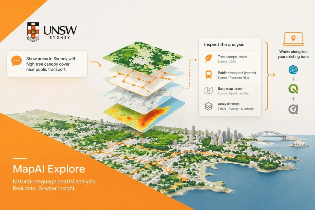

UNSW’s MapAI Explore has launched in Australia, letting users pose place-based questions in everyday language and receive maps with the data sources, assumptions and analysis steps exposed. The UNSW announcement describes a workflow that searches datasets, combines them and runs spatial analysis—aiming to reduce the preliminary data-gathering work that can delay planning and infrastructure assessments.
Example questions include which schools fall in bushfire-prone areas and how much residentially zoned land lies within 800 metres of a train station. The platform draws on public datasets, including Australian Bureau of Statistics and New South Wales property, infrastructure and zoning data. Users can refine questions, review the datasets behind an analysis, and, according to the announcement, save workflows and export geospatial information for reporting and consultation.
A GIS companion, not a replacement
UNSW and MapAI present the product as a layer alongside existing mapping software and GIS specialists. MapAI’s product information names ArcGIS, QGIS, spatial databases and organisational data as environments it can work alongside. Its current site also describes exporting maps, CSV and GeoJSON for reports and briefings. These are vendor-described capabilities, not independent performance findings. The supplied product information does not specify compatibility with public ArcGIS REST services or host or version compatibility.
In the review workflow, a GIS specialist should check the selected data and method before a result is used for planning or infrastructure decisions. Individuals can start free with a monthly credit allowance; organisations can request structured trials.
My view is that the evidence trail is more consequential than the chat interface. A conversational prompt can make GIS analysis easier to initiate, but planning teams still need to check whether the selected datasets are current, appropriate to the question and aligned with approved methods. MapAI’s current product information describes source details, analytical steps and assumptions as inspectable. I would make that verification—and whether a specialist-approved workflow can be reused—the first practical evaluation, rather than judging the tool by how quickly it produces a map.
My concern is that an 800-metre straight-line buffer could overstate walkable access by including places that are close on a map but not reachable by a comparable walking route. This is an inference, not a reported MapAI result. If the decision concerns walking access, compare the straight-line result with a network-based catchment before using it as evidence, and disclose any material difference.
Where the workflow may help
For planning teams, the main opportunity is reducing repetitive work across fragmented datasets before analysis begins. A planner could use a natural-language question to assemble a first-pass view of housing, transport or infrastructure evidence, then ask a GIS specialist to review the inputs and method. That could make exploratory analysis more accessible without making the resulting map a substitute for professional review.
For CAD-led projects, the described workflow is a GIS evidence-preparation step, not evidence of a CAD-native workflow. The product information describes exports for reports and briefings, but does not identify a CAD host, native CAD format or supported host versions. As an editorial inference, teams should confirm that the available handoff fits their project workflow before treating an exported result as ready for design use.
The announcement also describes HowWeSurvive, a map of more than 1,300 first-hand disaster-recovery accounts that can be filtered by location, disaster type, year and recovery stage. It illustrates a broader use of mapping to bring qualitative community evidence into planning discussions, though it is distinct from the platform’s spatial analysis of government datasets.
UNSW says MapAI grew from three years of research at its City Futures Research Centre. The specific point is that users can inspect the datasets and analysis behind resulting maps, while MapAI is described as accelerating repeatable GIS work alongside existing tools rather than replacing them.
Sources
- UNSW-developed AI tool makes complex spatial data easier to use — UNSW Sydney via VRITIMES
- MapAI — AI spatial analysis alongside GIS — MapAI